|
This is the introduction of Nanki-Kumano,
my home country on the southeast of Japan.
This area belongs to the World Heritage sites,
which UNESCO designated as
"Sacred Sites and Pilgrimage Routes
in the Kii Mountain Range," in 2004.
I hope the following information of my own
will help overseas people get to know
about traditional Japanese cultures more and more,
and visit such local areas much more in the future.
|
|
| Click the link part, and the new window will appear. |
|
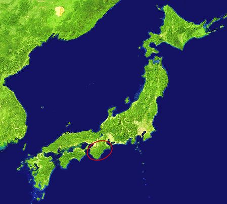
Map of Japan
Kii Mountain Range and Nanki-Kumano
in the red circle |
|
 |
|
|
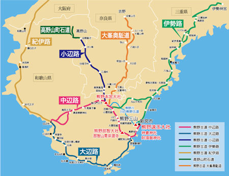
The southern part of the Kii Peninsula is called “Kumano.” It is a collective
term for the Nanki region of Wakayama Prefecture and parts of the adjacent
Mie and Nara Prefectures, belonging to Yoshino-Kumano National Park.
This plaza, “Nanki Kumano,” serves as an introduction to that region. Under the banner of “Nanki
Kumano,” it focuses primarily on my hometown, “Miwasaki, Shingu City, Wakayama
Prefecture,” and is limited to the area within the prefecture south of
Tanabe City, east to Kumano City in Mie Prefecture, and north to the area
around the Doro Gorge and Kumano Hongū Taisha Shrine.
Even so, this region is remarkably blessed with historic sites, shrines, and temples. The several branches of the Kumano Kodo connecting them are not only scenically beautiful but also evoke the history of bygone days.
My hometown, “Miwasaki,” is nestled between the sea and low mountain ranges,
a place as small as the forehead of a cat. Facing the Pacific Ocean and
the Kumano Sea, it lies along the Kumano Kodo Ohechi route. It is a peaceful
countryside blessed with the blue of the sea and the blue of the mountains,
even praised in the ancient Man'yō-shū poetry anthology.
The “Koyanozaka” section of the Kumano Kodo is a mountain path less than
2 km long, leading from the small port town of Miwasaki along the Kumano-nada
seacoast towards Shingū. With a bit of hometown bias included, it's
my personal favorite in this region.
Translated into English
from the Japanese version
under the help of DeepL.
|
|
|
Nanki-Kumano District
Southern Part of Kii Peninsula |
|
|
|
|
| Walking along Kumano-Kodo, as of August 2007 |
Nara Park, Mount Koya, Nakahechi Ancient Road,
Hongu Grand Shrine, Daimon Slope, Nachi Falls,
Nachi Grand Shrine, Seigantoji Temple, Koyanozaka Slope,
Futami Bay, Meotoiwa Rock, Ise Grand Shrine |
|
| Traveling around Nanki-Kumano, as of May 2009 |
Hongu Grand shrine, Hayatama Grand Shrine,
Nachi Falls, Nachi Grand Shrine, Seigantoji Temple,
Miwasaki Town, Taiji Whale Hall, Nachi-Katsuura,
Kushimoto Submarine Park, Hotel Urashima |
|
|
|
Miwasaki, My Hometown
|
A coastal town in Shingu City,
located in the southeast of Wakayama Pref.,
the prefectural border with Mie,
facing Kumanonada Sea of the Pacific Ocean. |
|
|
| Miwasaki Town |
Seashore, Obsevatory, Hachiman Shrine,
Suzushima and Kushima Islands, Kuroshio Park,
Sano Pine Grove, Days I was a Boy,
Four Seasons, How to Get to Miwasaki |
|
| Miwasaki Town's Highlights |
Koya-saka Slope along Kumano-kodo,
Kumano-nada Sea, Sandy beach,
Two Small Islands,
Village Festival, Whale Dance,
Eight Waka-Poems in Manyo-shu |
|
|
|
| Koyanozaka Slope |
One of the Kumano Ancient Roads,
among the UNESCO World Heritages
"Sacred Sites and Pilgrimage Routes
in the Kii Mountain Range" |
|
|
|
| Miwasaki, in the Poems of Old Days |
Introduction of Miwasaki and Sano Towns
in Manyoshu, the Oldest Anthology of Poems of Japan.
(8 waka, Japanese Poems, and Comparison of the 2 Poems) |
|
|
|
| Scenic Spots in Miwasaki |
Koyazaka (or Koyanozaka) Slope,
Sand Beach & 2 Small Islands,
Village Festival & Whale Dance,
Miwasaki and Sano in Manyoshu |
|
|
|
|
|
|
|
|
|
|
|