|
|
|
|
|
|
|
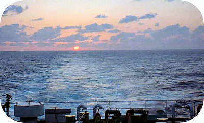 |
| Dawn of Kumano Open Sea, 2000 |
|
| 3. Particulars of Nanki-Kumano |
|
|
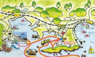
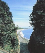
Shirahama, Kushimoto, Shionomisaki
Getting on the train of the Kisei Main Line from Osaka southward for Shingu,
you can see the sawtooth coastline on your right and the mountain range
of Kishu on your left all the way from around Wakayama City.
The train arrives at Kii-Shirahama station in two hours
Senjojiki, wide rock shore
Shirahama |
Shirahama is a well-known spa town as well as Beppu and Atami. The quality of hot
spring is colorless, transparent, alkaline. The temperature is 40-85 degrees
Celsius. It is said to be good to a gastrointestinal disorder, neuralgia,
women's diseases, etc.
The shore scenery of Shirahama is excellent, especially Senjojiki, Sandanpeki
rock shelves and Engetsu Island, etc. along the violent seashore, as well
as the hot spa.
Spa towns continue from Shirahama down until Susami via Tsubaki.
The coast line from Susami until Kushimoto is called Kareki-nada or Dead-tree
Open Sea. This name of the open sea is also the title of a novel by Kenji
Nakagami, a famous writer from Shingu City.
Kareki-nada may remind you from the name (dead trees) of a desolate and severe seashore,
however in fact, the sea is endlessly blue, bright and calm. Inlets like
labyrinths eroded by waves and small fishing ports appear one after another
along the coast line.
Kushimoto is a port town, and the entrance to Cape Shionomisaki, the utmost southern
place in the mainland of Japan.
This town is also famous for the traditional folk song "Kushimoto-bushi."
This is Kushimoto and the opposite is Ohshima Island.
Our go-between is a cruise ship.
Ara yoisho yoisho
yoisho yoisho yoisho.
There is a lighthouse at Shionomisaki. But it doesn't light up the dark
road of love.
Ara yoisho yoisho
yoisho yoisho yoisho.
------
|
 |
The folk song used to be right, as you could see Ohshima Island from the
port of Kushimoto. Cruise ships were coming and going just like your go-between.
Lately in 1999, a nice bridge was built between the Cape Shinomisaki and Ohshima. No cruise ship may have been running since then. (It is true, no cruising boat in 2004.)
In addition, there are several other nice spots for tourists in Kushimoto,
like the Submarine Park, Hashiguiiwa, a very strange chain of rocks.
Cape Shionimisaki is south of Kushimoto, 20 minutes by bus. Situated in latitude 33 degrees
26 minutes north, it is the most southern place in Honshu (the mainland
of Japan). The grassland of the cape is called "Bourou-no-shiba",
spreading toward the sea with no obstruction. The contrast of its fresh
green and the blue of the Pasific Ocean shows you just a southern country.
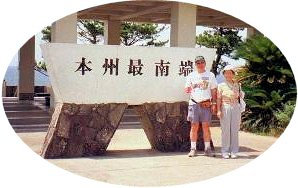
the southernmost place
of the mainland of Japan
The end of the grassland to the south is a steep precipice of 60 meters, falling away vertically. Look over it, and you will realize wild waves are breaking on the rocks. The sea sprays show you simple and fierce nature.
Turning your eyes to the right, you will see the white light house watching
the sea. It is what is in the "Kushimoto-bushi" folk song.
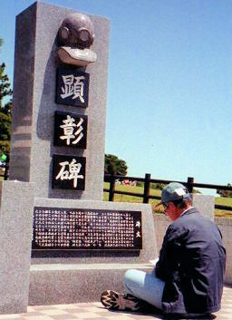
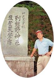
Memorial Monument
The memorial monument was built in the "bourou-no-shiba" lawn
in 1998. It is the monument on the people of Kushimoto town who worked
as pearl divers at the Arafura Sea north of Australia.
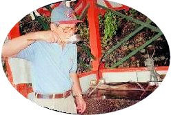
My father was a pearl diver there for 17 years from the age of 16. After
he came back home, too, he was related to the Arafura Sea as an owner of
the ship "Hinomoto-maru."
When I found this monument in April 2000, my heart got full of deep emotion.
Because I remembered what my father talked about in his large bed, with
his children on his both sides, during my elementary school days. The talk
about a coral reef, a paradise of tropical fishes...... The talk about
Thursday Island, a little bit north of Cairns, Australia, where he stayed
a lot of times, the remembrance with islanders, baptizing by Father Bike......
All of them invite me into a nostalgic dream even now.
The monument inscription was as follows.
|
This monument was built for honoring and remembering forever the great
achievement of the people of Kushimoto and the vicinities who worked as
pearl divers in the area of sea around Australia and unluckily died there,
and who contributed the development of the pearl industry around there.
Our Japanese people contributed a lot to the development of the north Australian industry from 1878 to 1941 through the activities as divers gathering pearl shells, takase shells and sea cucumbers with the islanders, in addition to the discovery of fisheries and the improvement of the fishing method.
Following the memorial tower at Thursday Island, this monument was built
in memory of 100 years since the voyage Japanese fishermen started here
at this place with a view toward the faraway Australian sea, by the meeting
of promoters, the Kushimoto mayor as a chairman, subsidized by Kushimoto
town.
September, 1998
Memorial Monument Promoters
the grassland "Bourou-no-shiba"
Cape Shionomisaki, April 28, 2000
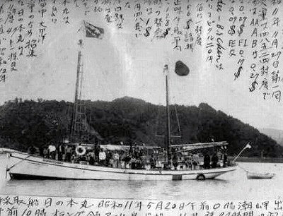 my father's ship "Hinomoto-maru", my father's ship "Hinomoto-maru",
May 1936 at Fukuro Port, Kushimoto
|
|
|
|
|
Taiji, Nachi-Katsuura, Shingu
The distance between Kushimoto and Shingu is 42 km, just one hour by an express train on JR Kisei Mainline.
There are picturesque places tied in a row, tempting you to get down from
the train.
Koza famous for Koza River, Taiji of a whale town, Yukawa and Katsuuara
of a spa, Nachi Falls, Nachi Grand Shrine, Ugui Port, and then my hometown
Miwasaki just before Shingu station.
The town "Nachi-Katsuura" has good sceneries lying between the
mountains and the sea.
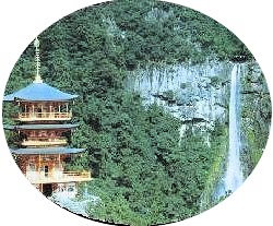
A local bus from Nachi station leads you to Nachiisan or Mount Nachi in 20 minutes. There are Nachi Falls, Nachi Grand Shrine and Seigantoji Temple there.
It is good to stay overnight at a spa hotel along the sea coast of Katsuura.
Katsuura has a famous seaport in Japan and is rich in delicious food from
the sea.
From Nachi station a local train eastward stops at Ugui, Sano, Miwasaki,
and then Shingu station.
Ohji Seashore, Shingu |
Shingu City is the most eastern part of Wakayama Pref. and the border with Mie Pref.
Kumano River, between the prefectures, starts from Doro Gorge, runs eastside
of Shingu and flows south into Kumanonada Open Sea . |
Shingu City prospered as a distribution center of lumbers in the old days.
Although it has repeated mergers of neighboring towns and villages in order
to maintain the enough appearance as a city, its population is as small
as 29,440, as of Nov. 2015.
Shingu now has no outstanding industry except a sightseeing foothold. The pulp and paper-making industries which were prosperous in the past are now diversified like the following. (as of May, 2000)
- Kishu Paper Manufacturing Company at Udono, the neighboring town of Shingu,
is doing well. (Its name was changed to "Hokuetsu-Kishu Paper Manufacturing
Company. Courtesy of Shingu City as of 2014.)
- Shingu factory of Tomoe Paper Manufacturing Company is no more here. Its
remains are now a vacant lot. The company itself is in good settlement
of account this year 1999, with the successful restructuring. (Its former
site is now a shopping mall. Courtesy of Shingu City as of 2014.)
- Honshu Paper Manufacturing Company was absorbed by Ohji Paper Manufacturing
Company in 1966. Its Shingu factory is going to be closed in 2000.
Public high schools are Shingu High School and Shingu Commercial High School.
I graduated from Shingu High.
Another Shingu High attached to Kinki University is also here, and teachers
are said to be traveling all over Japan in order to gather students.
There is no university here.
| Shingu is a tourist spot. |
|
Being the mouth
of Kumano River,
it's a starting point
up to Doro Gorge.
In the city, there are
Kamikura Shrine,
the Grave of Jofuku,
the Ruins of Tankaku Castle,
Hayatama Grand Shrine,
Koyanozaka Slope,
Miwasaki and Sano,
the ancient villages.
Near the city,
Onigajo Castle or
wild rocks facing the sea
in Kumano City.
|
Entrance to
Kamikura Shrine |
|
|
|
Doro-kyo Gorge, Hongu Grand Shrine
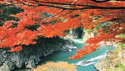
Doro-Haccho Gorge in autumn
Doro-kyo Gorge
Doro-kyo is about 100 km north of Kumano River from Shingu. Here is the
spot divided to three prefectures, Wakayama, Nara and Mie.
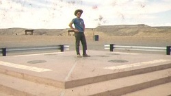 It reminds me of the Four Corners, the center of four states in the United States. It reminds me of the Four Corners, the center of four states in the United States.
I dropped by during my Penn State (Pennsylvania State University) days,
1969.
They are Colorado, New Mexico, Arizona and Utah.
Doro-kyo Gorge is called respectively Deep Doro, Upper Doro and Lower Doro
from up the stream.
Lower Doro is especially called "Doro-Haccho" showing heavenly beauty through the grace of God.
On both banks of the stream cliffs rise straight up, with everlasting dense
primeval forests on the back. No sooner the rock cliffs go away than other
cliffs get close to block your way. The stream is actually pretty fast,
however, it looks completely stand still.
The water, rocks and forests seen from the jet cruiser going up and down
are ink paintings by God.
Propeller cruisers were in service between Doro-Hacho and Shingu nearly until 30 years ago, 1970. They were twenty-passenger cruisers which advanced turning round the propellers with a diameter of over 1 meter on the back. The noise of a propeller was tremendously so big that a guide never announced while it was active. The conversation among the tourists were almost impossible.
This propeller cruiser used to be one attraction, though it was uncomfortable.
After it was transferred to a jet cruiser, the inside became considerably
calm. The guide can announce at any point through a microphone and tourists
can chat.
Hongu Grand Shrine
 Kumano Hongu Grand Shrine is located on the way up of Kumano River and
then Kitayama River, from Shingu to Doro-kyo. Usually the bus service on
the side of Wakayama Pref. from Shingu can be used to get there for one
hour and a half starting from Shingu City. Kumano Hongu Grand Shrine is located on the way up of Kumano River and
then Kitayama River, from Shingu to Doro-kyo. Usually the bus service on
the side of Wakayama Pref. from Shingu can be used to get there for one
hour and a half starting from Shingu City. |
It is really the shrine of God. Reaching the top of the long stone steps, appears the God Gate straight ahead, the Hall of Worship on the left side and the Shrine dedicated fourteen gods at the end.
The circumstances from the bottom of the stone steps are surrounded by
dense ceder woods grown straight high. The shrine on the top keeps deep
calmness.
This shrine has its solemn composure with a traditional ritual, so that
it reminds us of the ancient religious days when it was the center of the
Kumano-Sanzan or Kumano Three Grand Shrines.
(You can see the model of a whale catcher boat of Miwasaki town in the old days on the way up of the steps. They caught whales in the Kumano Open Sea, particularly around my hometown.)
The Hongu Shrine is surrounded by hot spring villages, such as Kawayu,
Yunomine, Watarase, etc. You can enjoy simple spas in hotels and also on
the beach of the stream. The fee of a beach bath is 100 yen as of 2004.
There are many other scenic spots and historic places in and around Nanki-Kumano,
like Taiji of whales, Nachi Falls, Nachi Grand Shrine, Seigantoji Temple,
Kamikura Shrine in Shingu, Onigajo Castle of Kumano City, etc.
I take a rest about this chapter for the time being. August, 2004.
|
|
| Part 3 Reading 20' 14" |
|
|
|
|
|
|
|
|
|